iOverlander
- 3.9
- Rating
- 500.00K
- Installs
- Free
- Price

 Analysis by App-foxy
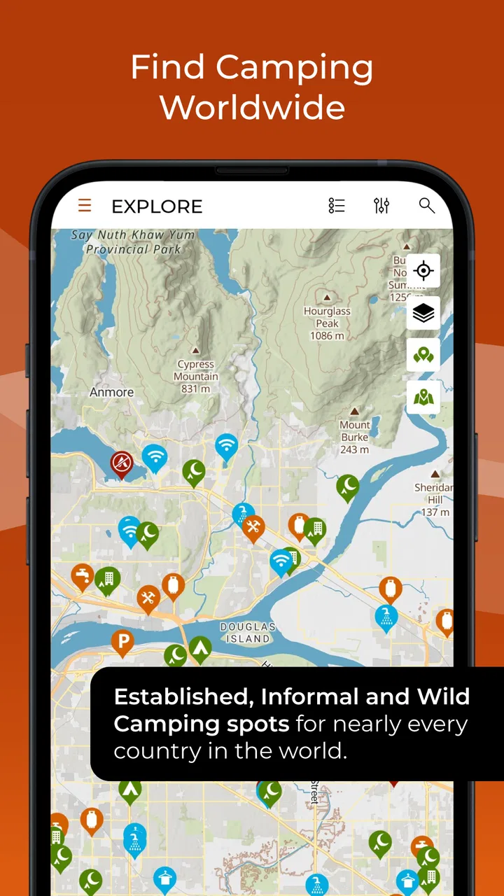
When I plan a long drive, the hardest part is often not choosing a route but working out where I can safely stop at the end of it. iOverlander is built around that very practical problem. It is a free Travel & Local app from iOverlander LLC that helps me search for camping and overnight stopping places, including destinations far beyond the usual tourist circuit. I found its value less in polished travel inspiration and more in turning a vague question—“where can I stay tonight?”—into a map of possible places to investigate.
The app has a 4.3 average from around 7,800 ratings, with more than 500,000 installs. Those figures suggest a well-established community rather than a brand-new experiment, but they do not remove the need for judgment. A campsite can change, access can become restricted, and a user-submitted note can age badly. My overall impression is that this is a useful field companion when I treat it as a discovery and verification tool, not as an unquestionable authority.
What using iOverlander feels like on an actual trip
The first thing that stands out is the app’s focus. It is not trying to be a complete holiday planner, a hotel marketplace, or a replacement for turn-by-turn navigation. Its central job is helping travelers locate places where they may camp, park, rest, or find useful services while moving through an area. That narrow purpose makes it especially relevant to people traveling by camper, van, car, motorcycle, or tent.
You May Also Like

 Blood Strike: 2.5 Anniversary
Blood Strike’s Loadouts Turn Every Drop Into a Tactical Gamble
A close look at Blood Strike’s custom loadouts: how fast access to signature weapons reshapes its battle royale rhythm, rewards preparation, and narrows the gap between fights.

 Pandora - Music & Podcasts
Pandora’s Music Is Easy to Start, but Harder to Recover
Pandora’s strength is its low-effort path from a seed to a station. Its weak spot is how much confidence it asks you to place in connection, setup, and quiet recovery.

 8 Ball Pool
 Is Built on Rivalries, Rematches, and Routine
A close look at the rivalries, rematches, shared routines, and unanswered safety questions that turn a quick pool match into a persistent mobile community.

 Samsung Music
’s Quiet Strength Is Playing What You Already Own
Its reach comes less from spectacle than from dependable access to a personal library. That simplicity is both the app’s strongest retention engine and its ceiling.

 AccuWeather: Weather Radar
AccuWeather Review: A Quick, Clear Forecast for Everyday Decisions
For everyday plans, the best forecast is the one you can understand quickly. AccuWeather makes rain timing, radar, and local conditions easy to act on, with a few trade-offs.

 Hill Climb Racing
Why Hill Climb Racing Still Turns Crashes Into One More Run
A tiny car, a bumpy hill and one more upgrade: Hill Climb Racing keeps resurfacing because its simple chaos makes every near-miss feel personal.
More From Our News Desk



On a normal trip, I would use it before leaving a town rather than waiting until the fuel light or sunset creates pressure. I can look ahead along the route, compare several possible stops, and keep a backup in mind. That small change in workflow matters. Instead of searching from scratch after a long day, I can make a short list while I still have time to read notes and think about road conditions.
The remote-travel angle is where the app feels most distinctive. Conventional map apps are excellent at finding businesses, formal attractions, and established accommodation. They are less dependable when I am looking for a basic place to spend the night away from a major settlement. iOverlander is aimed at that gap. It can be more useful than a hotel-focused service when the trip itself is the priority and the destination is somewhere with limited conventional lodging.
That does not mean every marker represents a guaranteed campsite. I read each entry as a lead. The surrounding notes, the apparent location, the type of stop, and how recently the information seems relevant all affect my confidence. A pin on a map is only the beginning of the decision.
Why the community aspect matters
The app’s usefulness depends heavily on travelers sharing practical observations. A short note about access, noise, road surface, nearby facilities, or whether a place feels suitable for a particular vehicle can be more valuable than a glossy description. This is the kind of information I often want when official tourism pages are too general.
Community information also creates the app’s main weakness. User reports are lived experience, not a promise. One person may describe a quiet roadside stop as ideal, while another may find it uncomfortable or unsuitable for a family. Conditions can change quickly, especially at informal locations. I would never use a remote marker without considering a second option and checking the situation locally when possible.
A useful habit is to separate facts from opinions while reading. “The road is narrow” is a concrete warning. “The view is amazing” is personal preference. “There is water nearby” still needs care because availability, cleanliness, and access may be unclear. This approach makes the community content much more useful without expecting it to behave like professionally inspected accommodation.
How I would use it before leaving home
Before a journey, I would search the route in stages rather than trying to inspect an entire country at once. I would identify a preferred stop, a fallback, and a place where I could change plans if the road takes longer than expected. This is particularly helpful for travelers who do not want to reserve every night in advance but still dislike arriving without any idea where to go.
I would also compare the app’s suggestions with ordinary map information. A general map can help me understand the road network, fuel availability, shops, and access to a town. iOverlander can add the camping-oriented context. Neither view is complete alone. Combining them gives me a better sense of whether a location is genuinely practical rather than merely nearby.
For a first-time user, the temptation is to pick the closest marker. I think distance should be only one factor. A slightly farther location with a more suitable approach, clearer notes, and a better morning exit may be the smarter choice. This is one of the app’s less obvious strengths: it encourages me to think in terms of overnight logistics rather than just geographic proximity.
A realistic evening scenario
Imagine I am driving a camper after a delayed border crossing. My original destination is now too far away, and I need a stop before dark. I open the app, look along the remaining route, and find several possibilities. One appears close but has little useful context. Another requires a detour yet has clearer traveler notes. A third is near a town, which gives me a better chance of finding food or fuel if plans change.
In that situation, I would not simply select the nearest pin and follow it blindly. I would examine the approach, note any warnings, check whether the stop suits my vehicle, and keep the town option as a fallback. If the final access road looks doubtful, I would turn around early rather than treating the app as permission to continue. The application helps me make that shortlist; it does not make the safety decision for me.
That distinction is important for anyone asking whether the app can replace campsite reservations. In my view, it cannot. It is better for flexible travel, informal stops, and route discovery than for guaranteed availability. If I need certainty during a busy holiday period, a confirmed campground or hotel booking is the safer choice.
Trust begins with what the app lets me understand
Because this tool may be used while traveling through unfamiliar places, trust is not only about the number of map markers. I also want to know what I am choosing, what information I am sharing, and which decisions remain under my control. The app is most comfortable for me when I use it deliberately: I review a location, decide whether to act on it, and avoid granting more access or revealing more personal detail than the task requires.
The available product details identify it as a Teen-rated app, and the current version is 2.6.36. It supports devices running Android 7.0 or later. Those details are useful for compatibility, but they do not tell me whether a particular phone will feel fast in the field. Travelers should install and test it before a major departure rather than discovering compatibility or performance problems beside an unfamiliar road.
The developer is listed as iOverlander LLC. I appreciate having a clearly named organization behind the application, but a developer name alone is not a complete trust assessment. I still pay attention to the permissions requested during installation or use, the wording of any location prompt, and the choices shown when I contribute information. If the app asks for access that does not seem connected to finding or recording places, I would pause and review that request instead of accepting automatically.
Handling location-sensitive moments carefully
A travel app naturally becomes more sensitive when location is involved. Searching for a campsite can reveal where I am going, while contributing a report can reveal where I have been. I therefore prefer using location access only when it directly improves the task, and I review the device’s permission controls rather than leaving settings untouched forever.
This is not about assuming that the app misuses information. It is about recognizing that travel data can be personal even when it looks ordinary. A repeated pattern of searches, saved places, or contributions may say more about my movements than I intend. When I am traveling with other people, I also avoid posting details that could expose their routine or a private location unnecessarily.
Before sharing a new place, I would remove identifying details that are irrelevant to other travelers. A useful report should explain access and conditions, not disclose someone’s private address, vehicle details, or exact routine. This is a practical way to contribute responsibly while keeping the community useful.
I would also be cautious about treating a remote location as public simply because it appears on a community map. Land ownership, local rules, seasonal restrictions, and access rights can differ. If a place feels private, disputed, or unclear, I would not publish precise information merely to add another marker. The best contribution is not always the most detailed one; it is the one that helps travelers without creating problems for residents or land managers.
What the free model means in practice
The app is free to download and use as a starting point, which lowers the barrier for someone testing this style of travel. There are in-app purchases ranging from $9.99 to $99.99 per item, so I would check the purchase screen carefully before confirming anything. The presence of optional paid items does not automatically make the free experience poor, but it does mean I would not assume every function or convenience is included without reading the labels.
My advice is to try the basic workflow first: search for a familiar area, inspect several entries, and decide whether the information is useful for the kind of trips I take. Only then would I consider paying for an extra feature. This avoids buying on impulse because I am already tired, offline, or under pressure during a journey.
That also answers a common practical question: is it worth paying for if I only take occasional road trips? For an occasional traveler, the free access may be enough to judge whether the community and map coverage fit. For someone who spends long periods moving between remote areas, a paid option could be easier to justify if it provides a function that genuinely improves planning. The value depends on the trip pattern, not simply on the existence of an upgrade.
Where the app is stronger than ordinary alternatives
Compared with a standard map application, iOverlander is more directly aligned with finding unconventional overnight options. A normal map may show a campground as a business, but it may not present the same traveler-centered context around a simple stop or remote location. Compared with hotel-booking services, this app is better suited to people who carry their accommodation with them or prefer flexible stopping points.
It is also different from a dedicated navigation app. Navigation software is designed to guide me along roads efficiently. This app helps me decide which overnight possibility deserves attention. I would use them together: one for evaluating the stop, another for checking the route and driving instructions. Expecting one to replace the other would create avoidable frustration.
Formal campsite directories may be a better choice when I need verified facilities, reservation handling, clear pricing, or a dependable standard of service. iOverlander is more interesting when the journey is less structured and the useful answer may come from another traveler’s recent observation rather than a commercial listing.
Three habits that make the app more dependable
Build a fallback before committing to the first marker. I choose an alternative that is not merely nearby but practical if the preferred stop is closed, full, noisy, or difficult to reach. This prevents a single outdated report from controlling the whole evening.
Read access notes as carefully as destination notes. A beautiful location can be a poor choice if the final approach is narrow, steep, muddy, or unsuitable for my vehicle. I treat the last part of the route as a separate decision rather than assuming the map pin tells the whole story.
Contribute observations that will remain useful after the moment passes. I focus on durable details such as the type of vehicle that can reach the place, the character of the entrance, and nearby practical services. I avoid publishing sensitive information or presenting a personal impression as a permanent fact.
These habits reveal an important trade-off. The more flexible the destination, the more responsibility falls on me. The app can widen my options, but it cannot inspect every road, confirm every rule, or guarantee that a community report is still current. That is not a reason to dismiss it; it is the correct way to use a crowd-sourced travel resource.
Who should use it, and who should skip it
I would recommend trying it if I were speaking to someone who enjoys self-directed road travel, sleeps in a vehicle, camps outside conventional tourist routes, or wants more choices than the usual accommodation search provides. It is particularly appealing to travelers who are comfortable comparing information and changing plans when conditions do not match expectations.
I would be more cautious recommending it to someone traveling with a strict schedule, arriving late with children, or needing guaranteed bathrooms, electricity, reception, or accessibility. Those travelers may be better served by a confirmed campground, hotel, or official local source. The app can still help with research, but I would not make it the only plan.
It may also be a poor fit for a traveler who wants a completely polished, reservation-first experience. The strength here is discovery and flexibility, not removing uncertainty. If uncertainty itself is the problem, a structured booking service is likely the better primary tool.
My cautious verdict after using it as a travel tool
iOverlander earns its place on my phone because it addresses a specific problem that mainstream travel apps often handle poorly: finding plausible overnight options when I am far from conventional accommodation. Its free entry point, broad travel purpose, and community-oriented information make it useful for planning flexible routes and creating backup plans.
At the same time, I would never confuse a marker with a guarantee. I verify access, consider local rules, protect sensitive location details, and keep another option ready. I also review permissions and purchase prompts with the same care I would give any app that accompanies me through unfamiliar places. Those choices improve trust because they keep me in control of how the app is used.
The current release, version 2.6.36, supports Android 7.0 and newer, and the Teen content rating gives a general indication of its intended audience. For me, the deciding question is not whether it can replace every other travel tool. It cannot. The better question is whether I need a community-powered way to explore camping possibilities beyond hotels and formal booking platforms. If the answer is yes, this is a practical companion, provided I use its information as guidance rather than certainty.
I would install it before a road trip, test it in a familiar region, compare its suggestions with ordinary maps and local guidance, and learn how its controls feel before depending on it in a remote area. Used that way, it adds useful flexibility without asking me to surrender common sense.
FAQs for iOverlander
01What is iOverlander and what does it offer?
iOverlander is a community-driven app designed for travelers and adventurers looking for reliable information about camping sites, accommodations, and points of interest around the world. Users can explore detailed reviews, photos, and essential tips shared by other travelers, making it an invaluable tool for anyone exploring new territories.
02Is iOverlander available offline?
Yes, iOverlander offers offline functionality, which is particularly useful for travelers who may not have consistent internet access. Users can download maps and information before heading out on their journeys, ensuring that they have access to crucial data even when they're off the grid.
03How accurate is the information on iOverlander?
The accuracy of information on iOverlander largely depends on user contributions. As a community-driven platform, the app relies on travelers to provide up-to-date reviews, photos, and details. While it generally offers reliable data, users should cross-check with recent reviews and use personal judgment.
04Can I contribute my own experiences to iOverlander?
Absolutely! iOverlander encourages users to share their experiences by adding new locations, updating existing entries, and posting reviews and photos. This collaborative approach helps ensure the app remains a comprehensive and current resource for fellow travelers.
05Is iOverlander free to use, and are there any hidden costs?
iOverlander is completely free to download and use, with no hidden costs or subscription fees. The app is maintained by a dedicated community of volunteers, and users are not required to pay for access to its extensive database of travel information.
Pros
- Comprehensive database of camping spots.
- Offline functionality for remote areas.
- User-contributed reviews and ratings.
- Search filters for specific needs.
- Regular updates from the community.
Cons
- Interface can be a bit clunky.
- Some locations may lack detailed info.
- Limited support for non-English languages.
- Battery drain in GPS-intensive use.
- Occasional inaccuracies in data.

iOverlander
Gallery